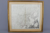

A map of China, Korea and the Japanese Isles, ca. 1779 SANTINI, Paolo, LEmpire de la Chine, avec la
A map of China, Korea and the Japanese Isles, ca. 1779 SANTINI, Paolo, L'Empire de la Chine, avec la Tartarie Chinoise d'après l'Atlas Chinois. Venice, Remondini, 1779. Original outline colour. 485 x 560mm. China, Korea and Tartary, also showing Japan and Ezo, published by Santini in conjuction with Rigobert Bonne of Paris. A large title cartouche of Chinese figures and ornaments fills the lower right. Incl. frame: 69 x 62 cm.
- The cost is converted to USD at the rate of 1 EUR = 1.13645 USD on 2015-10-12.
-
Sign in to view
Lot number
-
Sign in to view
Estimate
-
2015-10-12
Sale date
-
Sign in to view
Realised price
-
Sign in to view
Opening price
-
Sign in to view
House name
-
Sign in to view
Auction sale name
-
Sign in to view
Location
-
Categories
Sign in to view -
Tags
Sign in to view
SIMILAR AUCTION ITEMS