
[Maps, plans and views]. "Groodt Timoor". MANUSCRIPT MAP, pen and brown ink and watercolour, 18th ce
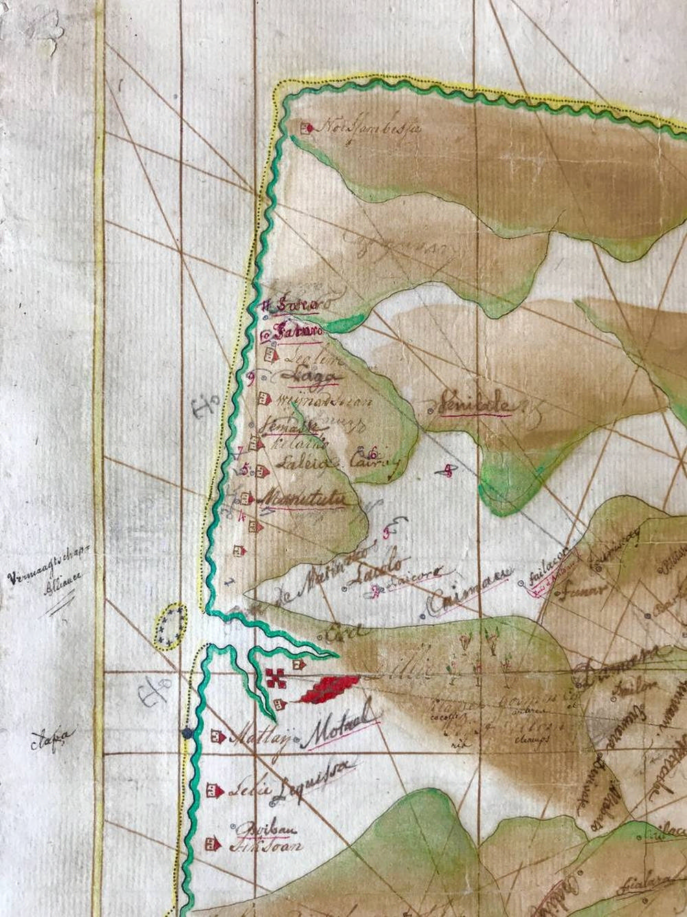
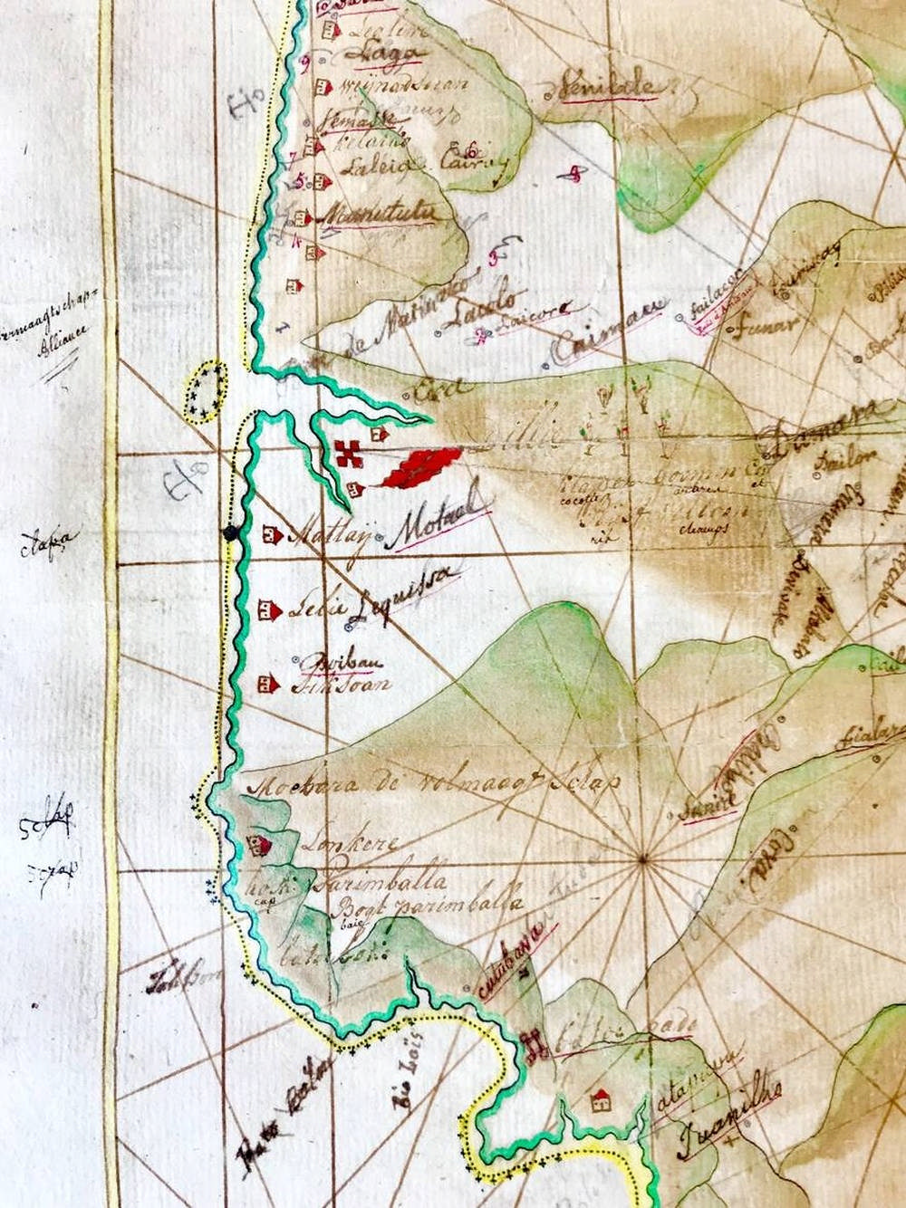
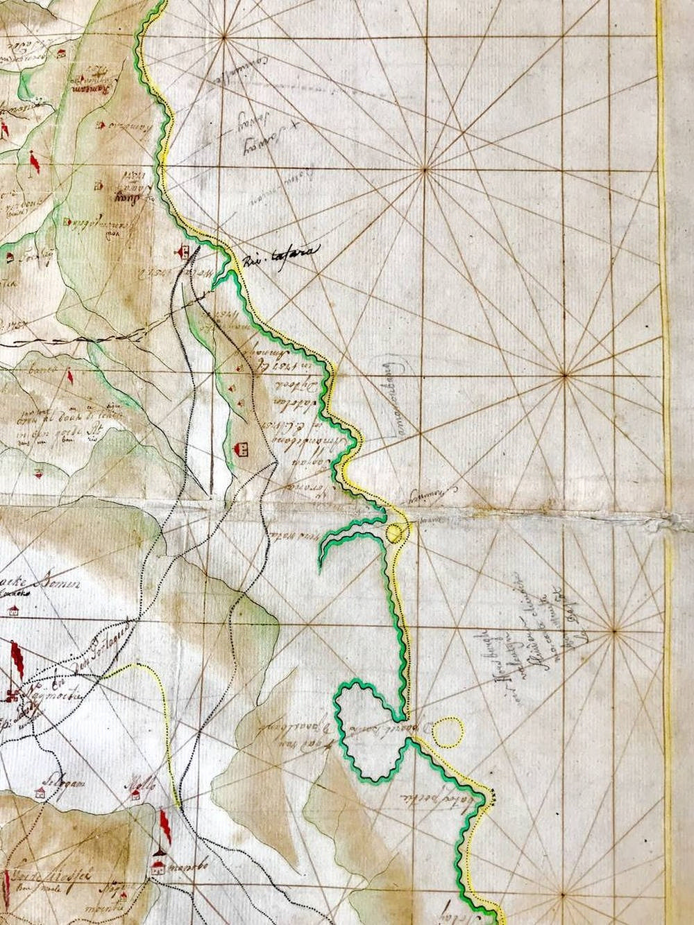
[Maps, plans and views]. "Groodt Timoor". MANUSCRIPT MAP, pen and brown ink and watercolour, 18th cent. w. 19th cent. annots. (in pen and ink and pencil) added in 2 diff. French hands, on 2 full and 2 half sheets of Dutch paper, with the watermark of J. Honig & Zoon (used from the early 1760s), 90x58 cm., w. compass rose and scale bar ("Duijtsche Mijlen 15 op een Graat") [approx. 1:450.000] in lower part. - Some vague foxing and a few sm. brown specks; lower margin sl. mouldy; professionally backed w. Japanese paper, resolving most of the following defects: split on horizontal middle fold, a few tears (occas. w. trifle loss of image / text), a few portions missing from blank margins. On the whole a remarkably well-preserved map. = Background. In 1756 the senior merchant and shabandar of the Dutch capital in the East, Batavia, Johan Andreas Paravicini (1710 -1771) a Swiss nobleman in service of the Dutch East India Co. was sent as high commissioner to Timor, in order to renew treaties between the Dutch and some 98 local rulers. As the settlement was run at a yearly defecit, ever since the early 18th. century a discussion was going on to make the island of Timor more profitable or politically useful, as for example watchdog over the sea routes to Banda and other spice islands. Timor, divided between Portuguese (North and East) and Dutch (South and West) hemispheres was known for products such as sandalwood, beeswax and tortoise shell. Against the background that hardly ever any of the European inhabitants dared to enter the hinterland, there was a growing interest to identify the local rulers and their specific territories. The map here presented was almost certainly prepared in connection with the expedition of Paravicini in 1756. A mapmaker was therefore embarked to survey the island. Although he lost his life when his ship (De Loper) perished in a storm on the Timor shore, most inventory and partly completed maps were saved. Another mapmaker was sent from Batavia to complete the work and he remained on the island until he finished his work. It is known that during the 1760s another mapmaker was still working on a map of the island, this time ordered by the local Dutch governor Hans von Pluskow, who was murdered while travelling over the island in 1762. After the mapmaker returned to the headquarters in Batavia, maps were sent to Amsterdam and probably further processed in the cartographic workshop of the Company in Amsterdam. Paravicini returned to The Netherlands where he arrived in 1760 and his whereabouts afterwards are largely unknown as he had no immediate permanent adress. When he died suddenly on a journey in France, in 1771, his nephew, colonel Johan David Paravicini ( 1718-1781), a military engineer from Maastricht, came to Paris to liquidate his extensive estate of which he was one of the heirs, as Paravicini had no legitimate children nor did he leave a will. The colonel discovered a large trunk with papers and documents regarding Timor and the Company, that Paravicini had taken with him from the East. He ordered the trunk to be sent to the Dutch Embassy in Paris, where it was received by the attachee Theo Loose. This gentleman confirmed the content, among which a large number of Timor and Batavia related documents was found. He promised to send these separately to Johan David Paravicini in Maastricht, in a letter dated 3rd of April 1773, “I will send these all to you and it will give you a couple of years of amusement to read it all”. After the colonel died in 1781, the valuable parts of the collections, that now belonged to the colonel and his wife Rosina Charlotta Pusch, were sold over time on the open market. So far four items have emerged, two famous drawings regarding the signing of the treaty and a celebration dinner, today in the collection of the Royal Tropical Institute in Amsterdam and one other drawing of fireworks in Batavia, initiated by Paravicini during the inauguration of the Governor General Jacob Mossel, recently sold at a local auction in Utrecht. The present map is the fourth Timor related illustration known so far from Paravicini’s time in the East, although there is no certainty it came directly from the Paravicini papers, as an inventory lacks. The map contains a large amount of toponymic, historical and agricultural as well as political details, linking it to the situation in the year 1757, the year after the new treaty came in use. The boundary between Portuguese and Dutch territory is marked in two positions. Many details of fortifications are drawn with the politicial allegiance of the independent villages beyond and flags identifying Dutch or Portuguese dependance, with a clear border line from North to South passing the village of Naij Moeti as the last Dutch dependency. Agricultural details are rich, marking in detail location of rice fields, coconut or ‘klapper’ trees and toeak trees (from which palm wine was derived). The coastline is marked in green, with sandbanks indicated by dotted areas and rocks by crosses and the sea is drawn with rhumblines. The later annots. are translations and notes on the accuracy of the topographical names, while reference is made to geographical books. An extremely rare, large manuscript map of Timor, probably the first ever made in which such detailed annotations of the interior of the island are specified. [Please note that this description contains updated information compared to that in the printed catalogue]. SEE ILLUSTRATION PLATE LXXXVI.
- The cost is converted to USD at the rate of 1 EUR = 1.116175 USD on 2019-05-22.
-
Sign in to view
Lot number
-
Sign in to view
Estimate
-
2019-05-22
Sale date
-
Sign in to view
Realised price
-
Sign in to view
Opening price
-
Sign in to view
House name
-
Sign in to view
Auction sale name
-
Sign in to view
Country
-
Categories
Sign in to view -
Tags
Sign in to view